Carian Way Starting Point

Directions
Similar places nearby
1 review
July 3, 2023
The Kara Trail (Ichmeler – Turunch – Amos route)
If you are brought to relax in Marmaris and its surroundings, you are bored with a hotel vacation and want a little extreme, then go trekking along the Karian trail. There is a lot of information about the trail itself on the Internet. This is a very famous trekking route covering most of Turkey. And it originates just in the village of Ichlemer, which is very close to Marmaris. We passed the first two passes from Ichmeler to Turuncha and from Turuncha to the ruins of the ancient city of Amos. And in the end, it turned out to be probably the most memorable experience of a holiday in Marmaris. But about everything in order.
Complexity. This route will not require any special skills from you. If you are generally a healthy person, you can walk for a long time and enjoy it, then you will cope. But do not frivolously assume that this is like a walk in the park. No. You will have to climb a lot of rocks, climb over fallen trees, wade through bushes, go down steep slopes and constantly monitor where you are stepping and what you are doing. There are plenty of places on the route where you can stumble and it won't end well. There will also be relatively flat areas, with an ordinary path where you can relax. The most important thing on the route is to carefully monitor the red and white signs that mark the trail. Sometimes, in addition to markers, arrows are even drawn showing in which direction to look for the trail next, as well as red crosses that show that it is not worth going there. Pyramids of stones can also be seen next to the markers to attract more attention. In general, it is difficult to get lost, but at the same time there will be a couple of places where you need to be very careful. In one such place, we spent 30 minutes climbing through all the bushes to find a continuation of the trail. As a result, it was just heavily overgrown with a high path, and above the path there was a large bush that formed a single green wall together. No wild animals were seen on the trail. All sorts of insects didn't bother me either.
Preparation. Naturally, you need to take a lot of water and sun protection with you. We were walking on June 14th and the heat had not been so strong yet. But in July and August, they say, the heat increases significantly. In addition to provisions, it is necessary to have an offline map of the trail with GPS navigation. I used the free MAPS ME app. In fact, the trail in the app and on the ground coincide by 99%. It is very convenient to navigate. You only need to walk in closed, sturdy shoes. It is also better to close the sleeves and legs. Otherwise, you will be covered in scratches. Sometimes you have to wade right through the branches of bushes, and on these branches there are often thorny vines with powerful thorns. By the way, you will always need a small sharp knife to cut these vines if possible.
And, actually, the route itself.
Part 1. Ichmeler – Turunch.
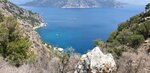
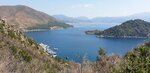
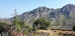
At the entrance to the route, we were met by a small herd of cheerful goats. And we didn't meet a single living soul on the whole route. Immediately after the start, the trail rises steeply. It winds between the rocks and guides you to the top of the pass. Here, navigating the markers does not cause any problems at all. There are many beautiful locations for photos in the process of climbing to the top, and of course you will be rewarded with a stunning view from the top of the pass to the bay. After the top, you will have a short descent and ascent, as if into the hollow of the pass. At the beginning of this descent, we just lost the trail, as I wrote above. After that, there will be a long gentle descent, relatively comfortable for walking, you can increase the pace, but always keep a close eye on the markers. Again, there will be plenty of places for good photos. Just before the village of Turunchus, the trail branches off. Focus on the part of the trail that will take you closer to the coast faster. There is a cafe for lunch in Turuncha and a very clean sea. This section took us about 4 hours, taking into account the loss of the trail and several photo shoots.
Part 2. Turunchus – Amos.
After lunch and shopping, we crossed the village and came to the beginning of the second section, which should lead us to the ancient city of Amos. This part of the route is probably even simpler than the first one in terms of terrain, but it is much more difficult in terms of orientation on the terrain and finding those very markers. And here's the thing. The local authorities apparently decided to refine this part of the trail. To make it available for more mass visits. To do this, they began to cut down clearings in order, apparently, to make cultural paths there in the future. But at the moment there are no cultural paths, nor those same red-and-white markers. Cutting through the next clearing, the markers were lost. You end up walking along the path, then along the clearing, but it ends in the most unexpected way because it has not been completed yet. Navigation shows that you have left the route altogether. There are no markers visible. As a result, the terrain completely does not correspond to the trail on the map. And in some places I just had to cut through the thicket, roughly guided by the fact that somewhere there, higher up the slope, there should be a trail on the map. In this place, the maximum number of scratches on the body and thorns on clothes was obtained! And all this continues until you reach the top of this pass. There, while the construction is being completed, and then all the way to Amos, you will go down a good path, perfectly seeing all the signs. Oh yes, the top of the pass is again a fantastic place with stunning views of the mountains and the sea!
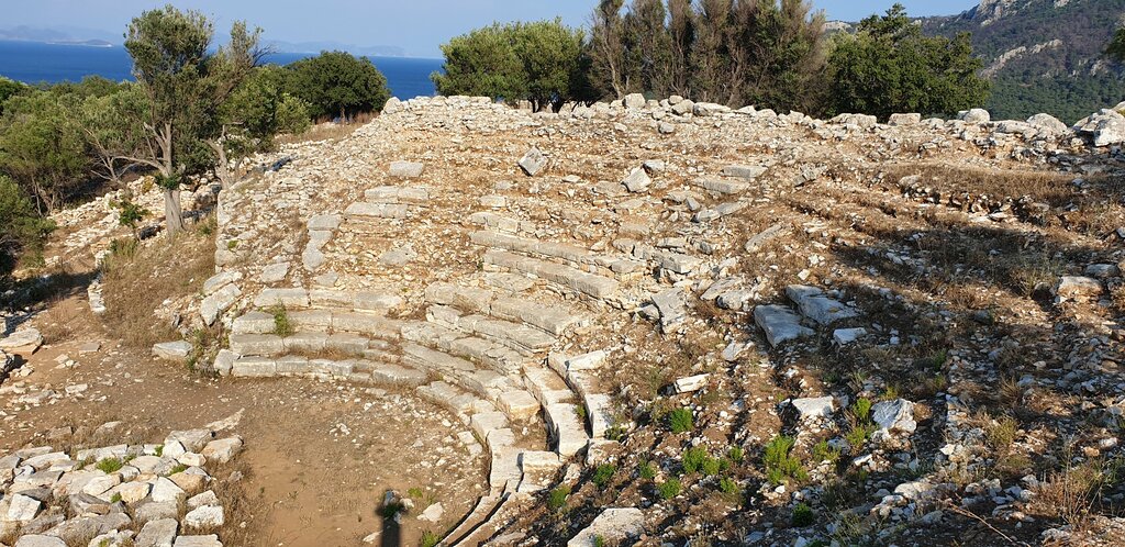
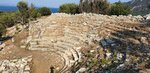
Amos is located on a promontory and is surrounded by ruins from the early Hellenistic period. A gorgeous, viewable place that we got to when the sun gives photographers the best light. This section, although a little shorter, also took 4 hours. And think in advance how you will return to Turunchu. You can walk 2.5 km. on the way, you can call a taxi, you can wait for the local bus, which has never passed with us.
See original · Русский


14